A significant winter storm is set to impact the Mid-Atlantic and Northeast regions of the United States from Saturday afternoon into Sunday morning.
States including Virginia, Maryland, Delaware, Pennsylvania, New Jersey, much of New York, and all of Southern and Southeastern New England are expected to experience heavy snow and potentially hazardous ice conditions.
Current Conditions and Immediate Forecast
Ahead of the approaching storm, the Northeast and Northern Mid-Atlantic states are experiencing windy conditions. A weather front accompanied by an upper trough is moving through the area, bringing colder air in its wake. Some regions are witnessing snow showers ahead of this cold front. Overall, the day is expected to be cloudy to partly sunny, with temperatures holding in the middle to upper 30s (1-3°C) north of New York City and upper 30s to lower 40s (3-5°C) elsewhere.
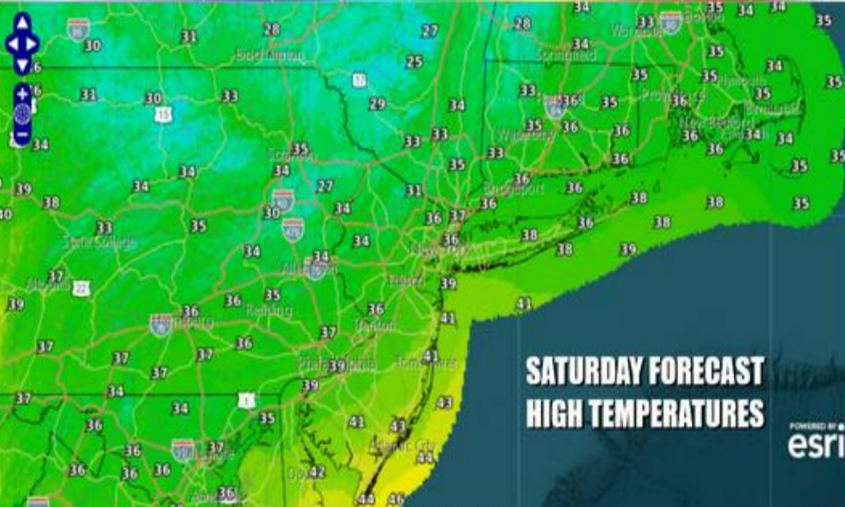
Tonight, skies will clear gradually, and winds are anticipated to diminish slowly. Low temperatures will drop to the upper teens (-7 to -8°C) inland and low to mid-20s (-4 to -6°C) along the coast and in warmer urban areas. Saturday will start with some early sunshine, but clouds are expected to increase rapidly ahead of a low-pressure system moving eastward across the Ohio Valley. Highs on Saturday will be in the low to middle 30s (1-2°C).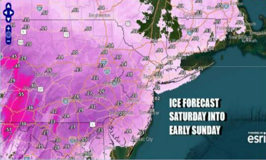
Storm Development and Expected Impact
The low-pressure system is projected to move into West Virginia on Saturday night and redevelop off the Delaware coast. From there, it is expected to head east-northeast, passing south of Long Island between Saturday night and Sunday morning. This system is anticipated to behave similarly to the one experienced on Thursday; however, this time, there is more cold air both at the surface and aloft. Additionally, the system is more robust, with better dynamics conducive to snow formation.
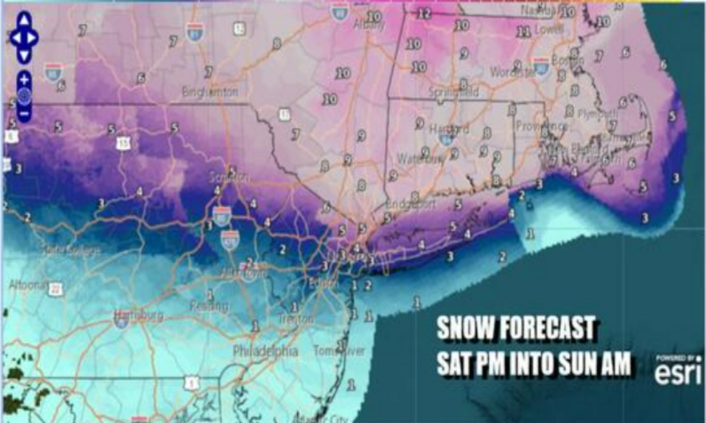
Snow is forecasted to develop across Southern Pennsylvania and Southern New Jersey by midday Saturday, reaching New York City by mid to late afternoon, and extending into Southern New England by late afternoon and evening. Southern areas across Pennsylvania into Central and South Jersey are expected to transition to sleet and freezing rain (with rain along the coast), while a significant snowfall is anticipated Saturday evening in the Hudson Valley, Long Island, and Southeast New England. The changeover to sleet could reach areas in New Jersey around Interstate 78, as well as New York City and Long Island, though this remains uncertain at this point.
Snowfall and Ice Accumulation Predictions
Current projections align closely with the National Weather Service for inland areas north of the coast. Along the coast, however, there is some caution, leading to slightly lower snowfall estimates for New York City and Long Island at this time. In parts of Pennsylvania and New Jersey, there is a concern for significant ice accumulation, with ice accretion potentially reaching a quarter of an inch and, in some places, over half an inch. Temperatures on Saturday night are expected to hover between 27 to 34°F (-3 to 1°C) during precipitation. The storm is expected to move away early Sunday morning, followed by improving weather conditions later in the day, with highs in the 30s (1-3°C).
Looking Ahead
This active weather pattern is expected to continue into next week, with another chance for snow later on Tuesday into early Wednesday, and again at the end of the week.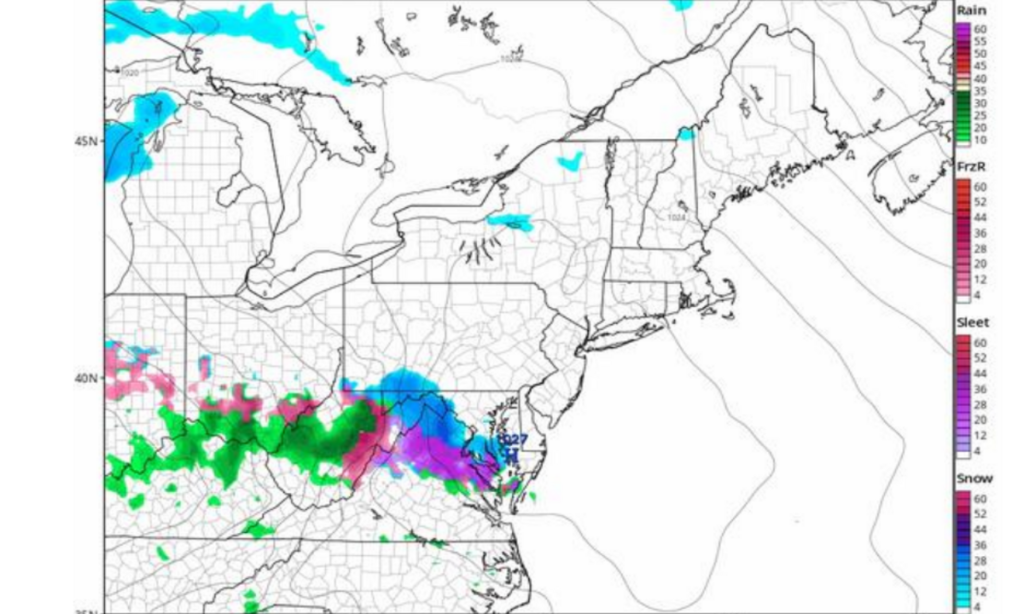
Preparation and Safety Recommendations
Residents in the affected areas are advised to monitor local weather updates and prepare for potential travel disruptions. It’s essential to have emergency supplies on hand, including food, water, and medications, in case conditions deteriorate. If travel is necessary, exercise caution, as roads may become hazardous due to snow and ice. Ensure vehicles are equipped with winter essentials, such as blankets, ice scrapers, and a full tank of gas. Additionally, check on neighbors, especially the elderly and those with limited mobility, to ensure their safety during the storm.
Disclaimer—Our team has checked this article to ensure its accuracy and eliminate any misinformation. We are committed to providing clear and reliable information for our readers.