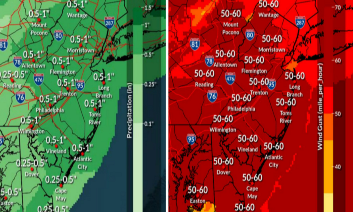
New Jersey is currently experiencing severe weather conditions, with powerful winds gusts causing significant disruptions across the state. As of Sunday evening, February 16, 2025, wind gusts have reached up to 71 mph in areas such as Atlantic City International Airport and Pennsauken.
These intense winds have led to widespread power outages, affecting tens of thousands of homes and businesses.
Impact of High Winds
The National Weather Service (NWS) has issued a high wind warning for most of New Jersey, which remains in effect until Monday evening. Residents are advised to secure loose outdoor items and exercise caution, as wind gusts are expected to range between 40 to 60 mph through the night. These conditions increase the risk of downed trees and power lines, which can lead to additional power outages and hazardous travel conditions.
Power Outages
The severe winds have resulted in significant power outages across the state. Jersey Central Power & Light (JCP&L) reported a sharp increase in outages, with numbers rising from 5,000 to 50,000 within an hour on Sunday afternoon. Overall, nearly 80,000 customers have been affected by power disruptions. Utility companies are actively working to restore electricity, but ongoing high winds pose challenges to repair efforts.
Transportation and Safety Concerns
The high winds have also impacted transportation and general safety. The New Jersey Department of Transportation has warned motorists to be vigilant for downed trees, branches, and power lines. Drivers are advised never to drive over downed power lines and to report such hazards to emergency services immediately. Additionally, outbound flights at Newark Liberty International Airport experienced delays of up to three hours due to the windy conditions.
Temperature Drop and Upcoming Weather
In addition to the high winds, temperatures are expected to drop below freezing, with wind chills making it feel even colder. Residents should prepare for the cold weather and potential for heavy snow later in the week, starting Wednesday night. The NWS advises staying updated with the latest weather forecasts and taking necessary precautions to stay safe during these severe weather conditions.
Safety Recommendations
Stay Indoors: Limit outdoor activities to prevent exposure to falling debris and hazardous conditions.
Secure Loose Items: Ensure that outdoor furniture, decorations, and other loose items are secured to prevent them from becoming projectiles in the wind.
Avoid Downed Power Lines: Never approach or drive over downed power lines. Report them to local authorities immediately.
Use Caution While Driving: High-profile vehicles are especially susceptible to being pushed or flipped by strong gusts. If you must drive, do so with extreme caution.
Prepare for Power Outages: Keep flashlights, batteries, and other emergency supplies readily available. Consider charging essential electronic devices in case of prolonged outages.
The current weather situation in New Jersey is serious, with high winds causing widespread disruptions. Residents are urged to stay informed through local news and official channels, adhere to safety recommendations, and exercise patience as utility crews work to restore power and services. Taking proactive measures can help ensure personal safety and minimize the impact of these severe weather conditions.
Disclaimer—Our team has checked this article to ensure its accuracy and eliminate any misinformation. We are committed to providing clear and reliable information for our readers.