If you have been enjoying the recent warm weather in South Carolina, you’re in for a treat! The pleasant, spring-like conditions will continue through Thursday, bringing above-average temperatures across the region.
However, a cold front is expected to move in by Thursday afternoon, bringing a slight chance of scattered showers and possibly a brief thunderstorm. By Friday, temperatures will dip slightly, but dry conditions will persist into the weekend and early next week.
Warm and Dry Conditions Hold Through Midweek
The current warming trend will continue as high pressure dominates the region. This system is bringing dry air and warm downslope winds, which will help temperatures climb into the low to mid-70s.
Today’s forecast: Clear skies and comfortable temperatures are expected, with daytime highs in the low to mid-70s. Overnight, a weak atmospheric trough may bring some mixing, but temperatures will remain mild, with lows dropping to the upper 30s to lower 40s.
Wednesday’s forecast: Another warm day is on the way, with temperatures reaching the mid-70s. Light southerly winds will bring in slightly warmer air, but humidity levels will remain low, keeping conditions comfortable. Skies will remain mostly clear, allowing for another beautiful day across the state.
Cold Front Arrives Thursday – Limited Rainfall Expected
By Thursday morning, a cold front will begin moving in from the west. Ahead of the front, winds will pick up slightly, and moisture levels will rise. However, forecasters predict that the air will remain relatively dry, which means rain chances will be low.
Thursday afternoon: The front may produce a few scattered showers and possibly an isolated thunderstorm, but widespread rainfall is not expected. Winds could become breezy at times, especially as the front pushes through the region.
Thursday night: As the front exits, temperatures will start to cool, but the dip will be minimal due to continued dry conditions.
Cooler Temperatures Expected Friday, But No Major Drops
Following the passage of Thursday’s cold front, temperatures will be slightly cooler on Friday. However, thanks to sunshine and downslope winds, the cooldown will not be drastic.
Friday’s forecast: Temperatures will be a few degrees lower, but sunshine will dominate the skies. Highs will remain near the upper 60s to low 70s, making for a pleasant end to the workweek.
Weekend Outlook – Mild and Dry Conditions Continue
Looking ahead to the weekend and early next week, temperatures will fluctuate slightly as weak frontal systems pass through the region. However, no major temperature swings are expected, and rain chances will stay low.
Saturday and Sunday: Expect mostly sunny skies with highs in the upper 60s to lower 70s.
Early next week: Dry air will continue to dominate, keeping rain chances minimal through at least the middle of the week.
Key Takeaways:
Warm temperatures will continue through Thursday.
A weak cold front may bring scattered showers Thursday afternoon.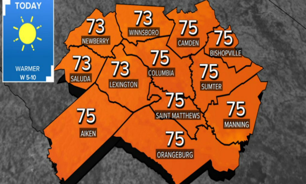
No significant rain is expected, and overall dry conditions will persist.
Cooler temperatures arrive Friday, but it will remain mild.
The weekend and early next week will feature fluctuating but comfortable temperatures with no major weather concerns.
If you’re planning any outdoor activities, this week is a great time to enjoy the beautiful weather! Keep an eye on Thursday’s forecast for any minor rain chances, but overall, South Carolina is in for a warm and pleasant stretch of days.
Disclaimer—Our team has checked this article to ensure its accuracy and eliminate any misinformation. We are committed to providing clear and reliable information for our readers.